![]()
DISCOVER MORE ABOUT NEMO AT OUR EDUCATIONAL SEMINARS
view calendar »
Joe Farrell
Delaware NEMO Coordinator
University of Delaware
Delaware Sea Grant Program
700 Pilottown Road
Lewes, DE 19958
(302) 645-4250
| Site Map
Toolkit > Conducting Natural Resource Assessments
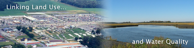
Natural resource-based planning is a process that puts the community’s natural resource base at the forefront. By identifying natural resources at the beginning of the planning process, your community can determine where development is most appropriate. This way, communities can avoid the unintended consequences of the typical planning process, such as open space becoming the “leftover” pieces, water resources being degraded, and community character being compromised.
A good comprehensive plan is a rational list of actions based on accurate information about your community. Inventories and assessments are a key step in the planning process because they will help guide the discussion about where development or other land uses should occur and what natural resources should be protected or restored.
A natural resource inventory (NRI) is the information collected to identify the location and character of natural resources.
A natural resource assessment (NRA) is an analysis of the NRI to aid in decision-making and management efforts.
An NRI is simply a collection of data represented by descriptive maps. It can include anything from a simple hand-drawn map to comprehensive, geographic information system-based, land-cover maps. Once an NRI is completed, the information collected can then be used to conduct an NRA to investigate local natural resource issues. When combined with cultural and economic resource inventories, the natural resource inventory can serve as a basis of a Community Resource Inventory (CRI). To learn more about CRIs and create your own based on watersheds in Sussex County, see “Build your own CRI”.
The next step is the analysis phase. The natural resource assessment or NRA is a separate activity from the inventory and usually involves the manipulation of the data in order to answer questions you have about your community. The first step in your NRA is to create a checklist of the analyses that should be conducted. This checklist will be based on community goals or concerns. The list may include imperviousness, forest cover and quality, flooding, wetlands, waterways, lakes, water quality, habitat and habitat corridors, endangered species, etc.
An NRA can range from a simple visual analysis to detect land-use patterns on a map to a complex water runoff model or determination of percent impervious cover.
For an example – using real databases on hypothetical development project in a local community see Conducting a Natural Resource Assessment.